
When the UK left the EGNOS1 programme on 25 June 2021, the most obvious and painful result was the withdrawal of LPV2 approaches in the UK. However, LPV are not the only GNSS3 approaches available in the PBN4 specification. Did leaving EGNOS lead to the removal of LNAV and LNAV/VNAV approaches too? Well no, but also yes. This article looks at some lesser known effects of leaving EGNOS which are currently open to interpretation and confusion.
In this article, we are going to look at:
- What leaving EGNOS actually means
- Guidance from the CAA
- What it means for GNSS approach operations
- Practical guidance for operators
Contents
What does EGNOS provide?
To work out what was lost, first we need to understand what we got from EGNOS from 2011 to 2021. EGNOS is part of European Space Programme and is based around transponders on 3 geostationary satellites, about 40 ground stations (RIMS) and 2 mission control centres (see EGNOS). Note some of the Ranging and Integrity Monitoring Stations (RIMS) are not in the EU – notably north Africa and the UK. The UK RIMS remain active despite the UK leaving EGNOS.
EGNOS provides provides an SBAS5 to improve basic accuracy of GNSS such as GPS and Galileo. It also provides integrity information which warns users when any signal is underperforming. For more information see the Pilots Who Ask Why article on PBN or the highly recommended PBN Manual produced by PPL/IR.
Core EGNOS services
EGNOS provides 4 core services to users:
- EGNOS Open Service (OS) – This service improves the accuracy of GNSS but no integrity or guarantees are made. This service can be used by anyone with the right receiver but must not be used for applications where safety of life is at stake. That includes all aviation.
- EGNOS Safety of Life (SoL) – This service includes both accuracy and integrity. It is for applications where a degradation in accuracy could risk life. Primarily it was designed to support LPV operations.
- EGNOS Data Access Service (EDAS) – EGNOS data over the internet primarily to support activities for non-safety purposes within surveying, mapping and construction.
- EGNOS Safety of Life Assisted Service for Maritime Users (ESMAS) – Basically SoL for ships
From this list, the one service that makes a difference in aviation is the SoL so let’s look in more depth this service.
EGNOS SoL for Aviation
The SoL was originally developed for aviation applications and the service was brought in incrementally as the technology matured. There are 3 levels of service with the SoL for Aviation:
- Non-Precision Approach (NPA) – This service level gives sufficient accuracy for 2D approaches such as LNAV and en-route navigation (eg RNP 1) – approximately accurate to 220 m laterally
- Approach operations with Vertical Guidance (APV-I) – This service level gives sufficient accuracy for 3D approach operations down to 250 ft minimums (eg LPV) – approximately accurate to 16 m laterally
- LPV 200 – This service level gives sufficient accuracy for 3D approach operations down to 200 ft minimums – approximate accurate to 3m laterally
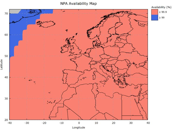
EGNOS SoL NPA Availability
These differing levels of service have different levels of accuracy as shown above. The way EGNOS increases accuracy is by working what errors are present in the baseline GNSS signal at specific locations (the RIMS). This error can then be broadcast so that SBAS receivers can correct for the known errors, improving accuracy. For the error correction to be valid over a specific area, there needs to be a local RIMS ground station so they are evenly spread across the operating area.
For the NPA service the accuracy require is not actually too stringent so this level of service can be provided relatively easily and actually quite far from a RIMS stations. Thus the service area for NPA is quite large. EGNOS provide maps of the service area for SoL in the EGNOS Service Definition Document (SDD). Note the UK is within this service area without any gaps:
EGNOS SoL APV-I Service Area
The APV-I level of service is a step up from NPA. The service area is shown below:
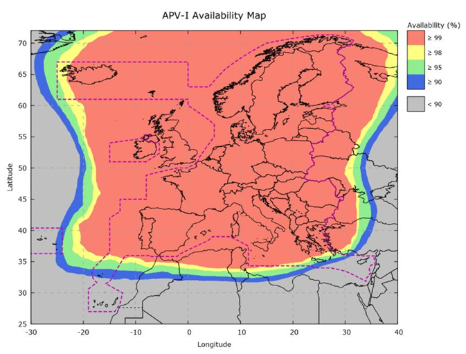
Again, the 99% availability of APV-I covers the UK. However, do you see the magenta line? That is a line denoting where EGNOS’ priorities lie in accordance with a statement in the SDD:
The EGNOS SoL Service for Aviation for areas beyond the region defined by this line is not ensured in the absence of an agreement since the EGNOS SoL Service for Aviation shall be provided as a priority on the territory of all Member States geographically located in Europe. – EGNOS SoL SDD
This is only a prioritisation issue not an availability issue. The APV-I SoL is available over 99% of the time over the UK. It has not been switched off. So if anyone powers on their SBAS GNSS device and selects SBAS on, they will get the improved accuracy. Before we ask “So what?”, let’s look at the LPV 200 availability map.
EGNOS SoL LPV 200 Service Area
The service area for SoL LPV service level is shown below:
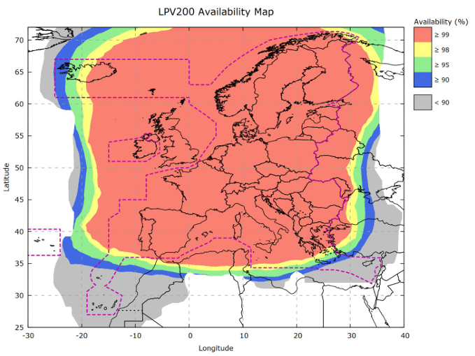
If you look closely you can see the total area has shrunk a little from APV-I, but not by much. Again, the UK is marked as outside the magenta line but is very definitely inside the red >99% availability area.
So we are inside the LPV signal area which has not been turned off – so why were all LPV removed from use in the UK?
EGNOS Working Agreements (EWA)
One of the primary functions of EGNOS is to provide integrity to the SBAS signal. If it goes wrong, operators need to know quickly for safety of life operations such as approach operations.
For LPV operations, in order to assure that information on the integrity of EGNOS could be passed quickly to Air Navigation Service Providers (ANSP) such as airports, there needed to be an agreement in place between the ANSP and EGNOS. Note the ANSP can range in size and scope as shown below.
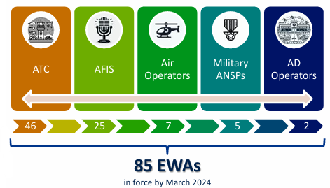
These agreements are called EGNOS Working Agreements (EWA). These EWA are contingent on the state being part of EGNOS. When the UK left EGNOS, all EWA for UK airports were rendered void and so all LPV had to be withdrawn.
But what about LNAV and LNAV/VNAV? They never required an EWA to be in place, so can they still be used in the UK?
LNAV and LNAV/VNAV without EGNOS
As already mentioned, UK ANSP cannot enter into an EWA with EGNOS so there can be no LPV in the UK. But the loss of EWAs was not the only consequence of leaving EGNOS. We need to look at the UK Government website regarding UK participation in the EU Space Programme.
There is a statement on the website, that reads:
The UK no longer participates in the EU Galileo or EGNOS programmes.
UK Government website
UK users should not use the EGNOS Safety of Life (SoL) service.
This clearly highlights that UK users should not use the EGNOS SoL. That means UK pilots should not use all elements of the SoL including NPA, APV-I and LPV. We already knew that we lost LPV, but have we lost LNAV and LNAV/VNAV too?
LNAV in the UK
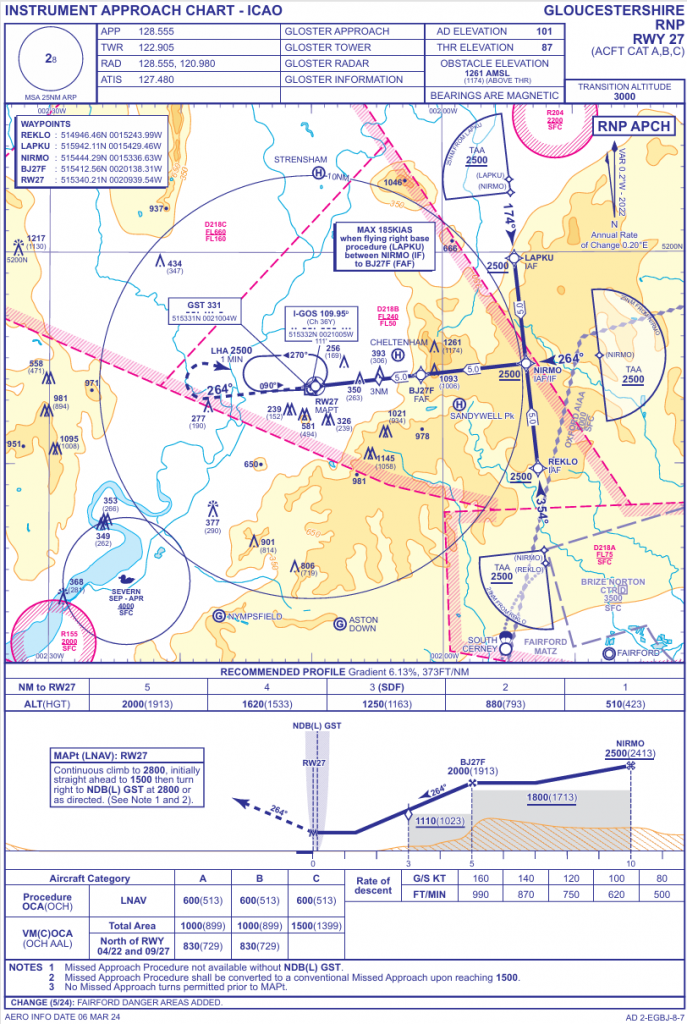
First, it should be immediately obvious from a glance through current UK approach charts that we have not lost LNAV despite not being permitted to use the SoL NPA level of service. For example, here’s an approach chart for Gloucestershire Airport’s RNP 27 which has LNAV minima.
The reason we can still achieve LNAV is that we can use ABAS6 in the form of Receiver Autonomous Integrity Monitoring (RAIM). RAIM can be used to complete the integrity check that was included in the SoL NPA service, so LNAV are possible. Incidentally, LNAV+V (LNAV with an advisory glideslope) can similarly be done without SBAS provided the GNSS is capable of it.
LNAV/VNAV (Baro) in the UK
An LNAV/VNAV (Baro) is an LNAV with a glideslope derived from barometric altitude data. This type of approach is available on many airliners and some helicopters (eg the AW169). The CAA have made it very clear, for example in this Clued Up article from 2021, that LNAV/VNAV (Baro) are still possible in the UK.
“As a result, pilots will need to make use of the other elements of the RNP instrument approaches, LNAV and LNAV/VNAV(BaroVNAV)…”
CLUED UP – GA Update – June 2021
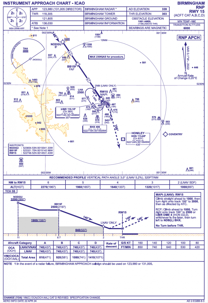
For example, at Birmingham you can see LNAV/VNAV minima are available
Again RAIM can be used to validate integrity for the lateral element so use of LNAV/VNAV (Baro) does not rely at all on EGNOS.
But there is another type of LNAV/VNAV to consider – the LNAV/VNAV (SBAS).
LNAV/VNAV (SBAS) in the UK
Whilst originally LNAV/VNAV used Barometric Altitude for the vertical guidance element, once SBAS became available it was realised by ICAO and the national aviation authorities that the vertical guidance could instead be derived from SBAS. Specifically the APV-I level of service is needed. We will come back to that later.
Certification of LNAV/VNAV (SBAS)
As SBAS VNAV was not originally available when LNAV/VNAV was introduced, a number of certification and regulatory hurdles needed to be cleared first. For example, the certification of avionics such as GNSS receivers needed to be tweaked. A Certification Memorandum was issued by EASA for legacy equipment originally certified under AMC 20-27 (see para 5.1 for a good background on the change) and the latest CS-ACNS was amended to cover future avionics.
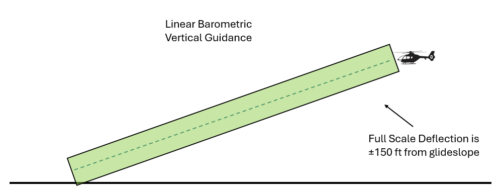
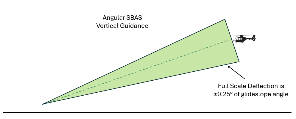
A key difference between an LNAV/VNAV (Baro) and an LNAV/VNAV (SBAS) is the nature of the vertical guidance. Barometric VNAV deflection is done in a linear way (you are allowed to be +75 ft or -75 ft of the datum). SBAS VNAV is done in an angular way (you are allowed to be within half full scale deflection of the datum glideslope). This is important in allowing use of LNAV/VNAV with SBAS.
Loading LNAV/VNAV (SBAS) Procedures
By allowing SBAS to be used for VNAV a whole swathe of already available LNAV/VNAV suddenly became available to suitably equipped aircraft. The approach needed to be appropriately coded into the nav database, by marking the “GNSS/FMS” parameter in the approach to “A” but this is only permitted if the change to an angular VNAV does not cause any issues (eg due to terrain)
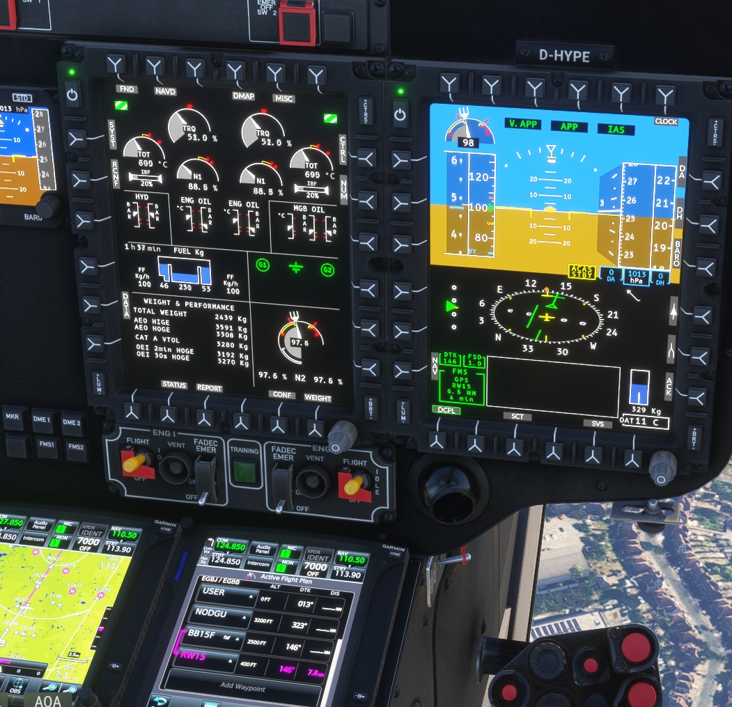
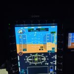
Let’s assume your avionics are certified for LNAV/VNAV (SBAS). An example of this is the H145 with twin GTN 750 or GTN 750 Xi. If you can load the LNAV/VNAV procedure on the system, so it must be compatible with angular vertical guidance. Let’s look if we can load in that Birmingham approach.
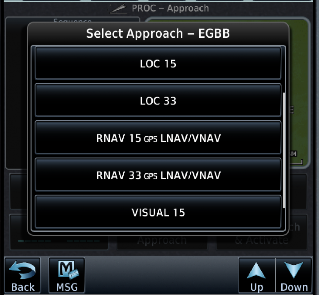
Yes we can! Great, we have a 3D RNP approach we can use. The H145 will happily provide guidance for the approach.

So we can fly an LNAV/VNAV (SBAS) then?
The Answer – LNAV/VNAV (SBAS) in the UK
So we can definitely load the procedure, the avionics are cleared for it and EGNOS SoL has not been turned off. If you also look closely at the CAA’s Clued Up article it states:
So, provided that the received signal is still indicating adequate integrity, pilots won’t be required to de-select the EGNOS signal from their GPS and the service can still be used in other flight phases.
CAA Clued UP ARTICLE
The article comes immediately after it mentioned LPV approaches so is “other flight phases” anything except LPV? So can we do an LNAV/VNAV (SBAS) with the CAA’s blessing?
Well yes you can do it but you probably shouldn’t. Remember earlier we said UK users cannot use the SoL signal? Yes, that includes the APV-I service which is part of SoL and that means you should not be doing LNAV/VNAV (SBAS) in the UK, despite it being possible on many aircraft.
Now the real head scratcher. What is a “UK user” from the UK Government’s statement? Does that mean UK operators are not allowed to fly this approach but an EU operator can use them? What about in the en-route phase? Sadly this is left unanswered.
This creates another problem – the aircraft do not know they are not allowed to fly LNAV/VNAV if the SBAS is left on as suggested by the CAA!
LNAV/VNAV (SBAS) Automation
If you load an RNP approach with LNAV/VNAV minima in the UK, it will provide a glideslope which will be used for guidance by the AFCS. The AFCS will couple to it. So what should the crew do? Deselect SBAS to force the system to only give LNAV guidance? Or should they deselect the VAPP mode to make it into a 2D approach operation? Neither seems sensible when the AFCS will do a much better job of following the glideslope.
Let’s look at what operators should do.
Guidance for UK Operators on LNAV/VNAV (SBAS) Operations
The first thing a UK operator needs to do is to understand if their machines can fly an LNAV/VNAV (SBAS). All Helionix machines with GTN 750 can do it (H135, H145) for example. Then the operator needs to make a decision on what they want their crews to do. There are a couple of options:
- Ban SBAS – Ban crews entirely from using SBAS by requiring it to be turned off. This goes against CAA guidance that SBAS can remain switched on and removes a check of GPS integrity which may cause issues with jamming, spoofing or flights into SBAS airspace such as Europe – not recommended!
- Allow SBAS to be on, but ban LNAV/VNAV (SBAS) – Crews must not use LNAV/VNAV guidance and must force the aircraft to force manual altitude guidance from the crew. This may be technically very challenging depending on the AFCS in the aircraft.
- Allow SBAS to be on and allow use of LNAV/VNAV (SBAS) guidance but restrict use to LNAV minima – Crews can couple up to the guidance but no lower than an LNAV approach. This is a good solution as it exploits the information provided and provides a smooth approach but limits the risk to no worse than an LNAV. There does need to be careful guidance on the actions at MDA – take a look at our CDFA article for more on this topic.
- Allow SBAS and LNAV/VNAV (SBAS) to LNAV/VNAV minima – This is skirting around bad practice that provides capability but at the huge cost of knowingly deviating from UK Government direction – now you’ve read the article you cannot forget it!
What does your operator suggest?
Conclusion
So a simple question required a little explanation, but in simple terms:
No, you cannot do an LNAV/VNAV (SBAS) in the UK. How an operator deals with that is crucial. Guidance must be provided!
Now take a look at our other articles.
- Engine Failure Training Mode – A safety tool that will punish the unwary
- Automated take offs – Pointless or are they the new standard?
- Keeping up with the Norwegians – Six amazing innovations for UK HEMS

- LNAV/VNAV (SBAS) – Are they approved for use in the UK?

- Helicopter 2D IFR approaches – Is CDFA the best choice?

- Understanding Helicopter Flight Manuals – Everything you need to operate safely

- Post Maintenance Flight Tests – How to avoid fatal traps

- First Limit Indicators in Helicopters – Deadly mistakes to avoid

- Bad Vibes – How to report vibrations on helicopters

- Autopilots, cross-checks and low G in helicopter unusual attitude recovery

- Expert site surveys – Improving the assessment of onshore landing areas

- Lights, helipad, action! The problem with new helicopter pad lights

- Helicopter on Fire – Could accident investigators have learned more?

- The Ultimate Medical Helicopter – Selecting the right machine for HEMS

- Deconfliction in HEMS operations – Practical methods for keeping apart

- HEMS Landing Sites – Reliable places to drop your medics

- Planning to fail – The perils of ignoring your own advice

- 2D or not 2D – How much room do I need to land a helicopter?

Leave a Reply